And what scenery! Even through a bus window on a blustery, showery day, it was amazing. This is the view from "Corkscrew Hill," the most twisty road in Ireland, at least according to our tour guide. Having spent most of my life in southern Appalachia, it's not easy to impress me with tight turns and steep grades, but this road managed to do the job. The gray color of the hills to the left is not bad color, it's The Burren, which was later in the day's agenda.
On our way to the Cliffs of Mohr, we drove through the little town of Lisdoonvarna - the town's not much bigger than the city sign. Its main claim to fame is a Matchmakers Festival, which as so many things have done in Ireland, has inspired a movie called, remarkably enough, "The Matchmaker." The Festival ended the weekend before, but there was still one matchmaker set up, trying to drum up some business.
Cliffs of Mohr
Running for 5 miles along the coast of County Claire, the Cliffs of Mohr (pronounced "more") are the the third highest sea cliffs in Europe - 650 feet high. (The highest are in County Donagal, which is the extreme northwest corner of Ireland) They are spectacular, even in the uncertain weather we were having. I could go on, but I'll just let the pictures do the talking. And if they look a bit familiar, this is where they filmed the sea cave scenes for "Harry Potter and the Half Blood Prince."
Running for 5 miles along the coast of County Claire, the Cliffs of Mohr (pronounced "more") are the the third highest sea cliffs in Europe - 650 feet high. (The highest are in County Donagal, which is the extreme northwest corner of Ireland) They are spectacular, even in the uncertain weather we were having. I could go on, but I'll just let the pictures do the talking. And if they look a bit familiar, this is where they filmed the sea cave scenes for "Harry Potter and the Half Blood Prince."
 | |||||
| Cliffs of Mohr looking south |
 | ||
| Cliffs of Mohr looking north with the mountains of Connemara on the horizon. |
We even had a couple of guys playing airs on their penny whistles - though their being huddled behind the walls out of the biting wind kind of killed the jolly effect.
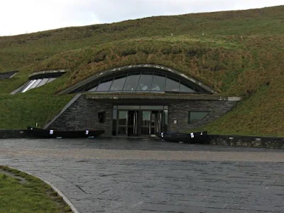
We had only 2 hours there, which went by like lightning. I wish we'd had more time to explore the exhibits at the Visitor Center, even if it does bear an unfortunate resemblance to the Teletubbies' lair. I kept expecting a periscope to pop out of the turf.
The Burren
It means "rocky place," and that it is. It's about 10 square miles of hill and coastline scraped to the limestone bedrock by glaciers, then eroded by rain and snow. This created a nearly continual sheet of stone above and an extensive set of caves below. People raise cattle and some sheep here, but mostly it is windswept and barren. An English surveyor working for Cromwell wrote of The Burren that it is "a savage land, yielding neither water enough to drown a man, nor tree to hang him, nor soil enough to bury him." Real cheerful guy, this 17th Century surveyor. Must have been the life of the party.
It means "rocky place," and that it is. It's about 10 square miles of hill and coastline scraped to the limestone bedrock by glaciers, then eroded by rain and snow. This created a nearly continual sheet of stone above and an extensive set of caves below. People raise cattle and some sheep here, but mostly it is windswept and barren. An English surveyor working for Cromwell wrote of The Burren that it is "a savage land, yielding neither water enough to drown a man, nor tree to hang him, nor soil enough to bury him." Real cheerful guy, this 17th Century surveyor. Must have been the life of the party.
 | ||
| Looking southwards back towards the Cliffs of Mohr. The boulder is an erratic, dropped by the glacier as it retreated. |
The ground was incredibly rough. In some places it seemed like the rocky covering was thin, with sharp-edged circles eroded into it. People actually fish off the rocks closer to the sea. A bit further down the road, we saw rocks with numbers painted onto them. This is where people staked out their spot and had actually sunk anchors so they could tie themselves to the rocks and not be swept away by the waves. Sounds crazy to me - all this to try to catch a fish?
 | |
Looking inland, the hillsides themselves are of this stone. The road runs past the end of this dry-stack wall. The guide told us that there were times when the spray from the sea would reach the bluff on the far side of the road. Considering the cliffs were well over 100 feet high here, that is a scary thought!
 | |
| Dunguaire Castle |
There were or course, signs, mostly at the Cliffs of Mohr.
Before we set out, our guide made it very plain that we were to stay well clear of the cliffs' edges.
I never did figure out what this one meant. Stay off the grass?
Do not pet the birds? It's a mystery to me!


